CORS FRS 300 Pro

CORS FRS 300 Pro
  • Models: FRS 300

Product Highlight

Reference Station

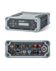
The geo-FENNEL Reference Station FRS 300 Pro is an easy-to-use system for creating your own reference network. Use in conjunction with other reference stations in a CORS network and stand-alone use are both possible.
With the geo-FENNEL Reference Station FRS 300 Pro, all available GNSS systems, such as GPS, GLONASS, GALILEO and BEIDOU can be used without effort. The integrated lithium-ion battery prevents data loss and continues to operate reliably until power is restored. The built-in web server makes it easy to modify receiver, status and firmware settings. User management can be created and monitored easily with the supplied software. The geo-FENNEL Reference Station FRS 300 Pro is the ideal partner for agriculture, deformation monitoring and surveying.

ART.-NO.: 752000

SUPPLIED WITH

  • geo-FENNEL GRU-Software

  • GAT 300 GNSS geodetic antenna ART.-NO. 752010
  • GAT 500 GNSS choke-ring antenna ART.-NO. 752020
  • 10 m cable ART.-NO. 752001
  • 30 m cable ART.-NO. 752003
  • 50 m cable ART.-NO. 752005

Signal Tracking

  • Channels, which are simultaneously tracked: 496
  • GPS: L1 C/A, L1P, L2C, L2P, L5
  • GLONASS: L1 C/A, L1P, L2 C/A, L2P
  • GALILEO: E1, E5a, E5b
  • BEIDOU: B1, B2, B3
  • QZSS: Yes (reserved)
  • SBAS: WAAS, EGNOS, MSAS, GAGAN
  • Time precision: GPS+GLONASS+BEIDOU 20 ns


Positioning Specifications

  • Static:
    – Horizontal: 3.0 mm + 0.1 ppm RMS
    – Vertical: 3.5 mm + 0.4 ppm RMS
  • Single-baseline RTK:
    – Horizontal: 8.0 mm + 1 ppm RMS
    – Vertical: 15.0 mm + 1 ppm RMS
  • Network RTK:
    – Horizontal: 8,0 mm + 0.5 ppm RMS
    – Vertical: 15.0 mm + 0.5 ppm RMS
  • E-RTK (< 100 km):
    – Horizontal: 0.20 m + 1 ppm RMS
    – Vertical: 0.40 m + 1 ppm RMS
  • DGPS: < 0.4 m RMS
  • SBAS: 1 m 3D RMS
  • Stand-alone: 1.5 m 3D RMS


Data Communication

  • 3 LEMO ports
  • One 2-pin LEMO port for power supply and battery charging
  • One 7-pin LEMO port (USB UART port) for system debugging and static data
    downloading
  • One 7-pin LEMO port (RS485 Protocol) for meteorological sensor/barograph/
    inclinometer connection
  • 1 DB9 male port: Standard RS232 protocol
  • 1 standard USB port: Connect with external storage card
  • 1 RJ45 LAN Ethernet port (10/100 Mbit/s) supports protocols HTTP, TCP/IP,
    FTP, NTRIP
  • 3 SMA male connectors
    – 1 PPS output
    – Event output
    – Reserve for Bluetooth® and W-LAN
  • 2 TNC connectors
    – GNSS-antenna connector
    – Frequency-marker oscillator input connector


Data Format

  • Correction data I/O: RTCM 2.X, 3.X, CMR & CMR+ (GPS only)
  • Position data output:
  • ASCII: NMEA-0183 GSV, RMC, HDT, VHD,
    GGA, GSA, ZDA, VTG, GST; PTNL,
    PJK; PTNL, AVR; PTNL, GGK
  • Extended NMEA-0183: BDGGA, GPNTR, GPCDT, GPHPR
  • geo-FENNEL Binary BINEX, RTCM3.X, compatible with major CORS software
    (VRS, FKP and iMax)


Data Logging

  • Loop recording function supporting long-term recording
  • Supports simultaneous data recording
  • Maximum 50 Hz data-logging rate:
  • Storage capacity:
    – 8 GB internal memory
    – Maximum 1 TB external memory
  • File format: RINEX 3.X, 2.X or geo-FENNEL
    Binary format
  • File log session: 5 / 10 / 15 / 20 / 30 min or 1 / 2 / 4 / 24 hour
  • Data retrieval and transfer: FTP and USB


Physical

  • Size: 202 mm x 163 mm x 75 mm
  • Weight: 2.4 kg
  • Housing: Sturdy aluminium housing


Environmental

  • Operating temperature: -40 °C to + 80 °C
  • Storage temperature: -45 °C to + 85 °C
  • Humidity: 100% condensation
  • Waterproof and dustproof: IP67
  • Vibration: MIL-STD-810G
  • Shockproof: Designed to survive a 1 m drop onto
    concrete


Electrical and Memory

  • Power consumption: 3.5 W
  • Power supply: 9.5-28 VDC, with over-voltage
    protection
  • Internal battery: 7.4 V, 8,800mAh, li-ion; 16-hour
    continuously working


User Interface

  • Front panel display: 4 arrow keys and data-entry power
    button, reset button and ESC button
    LCD display showing receiver’s status


    captcha

    © 2024Geoapplied Co.Ltd. All rights reserved.

    Powered by Insight Web Studio