FGS 1

FGS 1
  • Models: FGS 1
  • GPS System FGS 1 – Network Set (with DC6) & FieldGenius

    Price: $ 7767


    GPS System FGS 1

    Price: $ 5490

Product Highlight

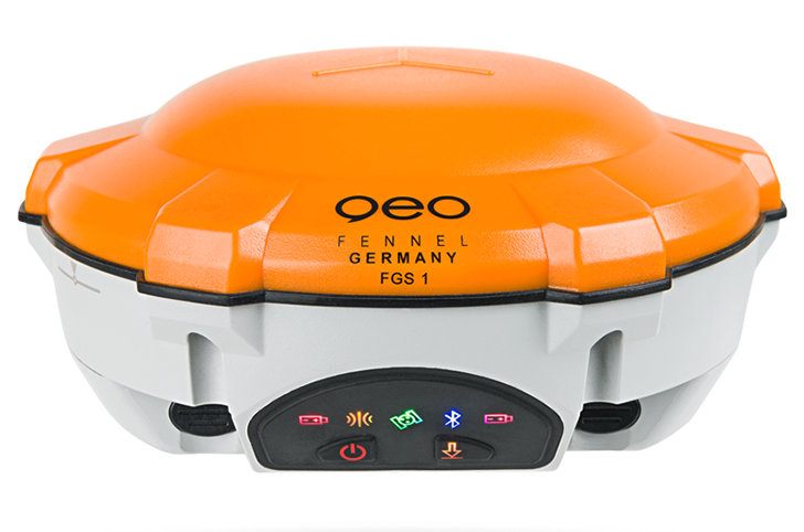
Unique GPS Set for multipurpose applications

The geo-FENNEL FGS 1 is a robust receiver designed for challenging environments integrated into a compact device that is lightweight and highly portable.

The FGS 1 can track all current working GNSS constellations. By using a unique algorithm it can operate in RTK mode combining all GNSS constellation signals or by using a single GNSS constellation signal such as GLONASS or BeiDou. The strong anti-interference ability of the receiver makes it possible to work in any environment. The FGS 1 integrates a cutting edge GNSS board, Bluetooth®, optional UHF (Rx & Tx) into a compact system. The smart design positions the FGS 1 among the lightest and most compact receivers currently available. The system is open to third party applications and supported by MicroSurvey FieldGenius and Carlson Surv-CE field applications.

ART.-NO.: 750100 ( Network-Set)
ART.-NO.: 751000 (Complete-Set)

  • High speed processing
  • Support for both post-processing and kinematic
  • Processing ability separate or to be combined with GPS, GLONASS and BeiDou
  • Supports downloads & use of precise ephemeris
  • Generation of various reports
  • User friendly


SUPPLIED WITH


GPS SYSTEM FGS 1 NETWORK-SET
ART.-NO. 750100

  • 1 GNSS Antenna FGS 1
  • 1 MicroSurvey Fieldgenius Software
  • 1 Fieldcontroller DC5
  • 1 Postprocessing Software
  • 1 USB-Cable for FGS 1
  • 1 RS-232 Cable for FGS 1
  • 1 Measuring Tape 3 m
  • 1 Container
  • 1 Operators‘ manual


GPS SYSTEM FGS 1 COMPLETE SET
ART.-NO. 751000

  • 2 GNSS Antenna FGS 1
  • 1 MicroSurvey Fieldgenius Software
  • 1 Fieldcontroller DC5
  • 1 Postprocessing Software
  • 2 USB-Cable for FGS 1
  • 2 RS-232 Cable for FGS 1
  • 1 Measuring Tape 3 m
  • 1 Tribrach AJ 10 black
  • 1 Tribrach Adaptor AL 11-D black with optical plummet
  • 1 Container
  • 1 Operators‘ manual
  • Signal Tracking
  • 256 channels with simultaneously tracked satellite signals :
    – GPS L1 C/A, L1/L2P, L5
    – GLONASS L1/L2
    – BeiDou B1, B2, B3
    – Galileo Yes, but not activated
    – SBAS WAAS, EGNOS, MSAS
  • Performance Specifications
  • Cold start : <50s
  • Warm start : <30s
  • Initialization time typically : <10s
  • Initialization reliability typically : >99,9%
  • Signal reacquisition : <2s
  • Positioning Specifications
  • Post processing static :
    – horizontal 2,5 mm + 0,5 ppm RMS
    – vertical : 5,0 mm + 0,5 ppm RMS
  • Real time kinematic :
    – horizontal : 8 mm + 0,5 ppm RMS
    – vertical : 20 mm + 0,5 ppm RMS
  • E-RTK (<100 km) :
    – horizontal : 0,20 m + 1 ppm RMS
    – vertical : 0,40 m + 1 ppm RMS
  • Code differential GNSS positioning :
    – horizontal : 0,25 m + 1 ppm RMS
    – vertical : 0,50 m + 1 ppm RMS
  • SBAS typically <1 m 3D RMS
  • Stand-Alone : <1,5 m RMS
  • Communication
  • 1 Serial port (7 Pin Lemo), Baud rates up to 921 600 bps
  • Radio modem (optional) Tx/Rx with full frequency rang from 410 – 470 MHz
    – transmit power : 0.5 – 2W adjustable
  • Positioning update rate : 1 Hz, 2 Hz, 5 Hz, 10 Hz
  • 5 LED Indicating lights Power, satellite tracking, differential data and data recording
  • Bluetooth®; V 2.X protocol, work compatible with Windows 7®, Windows mobile® and Android®
  • Data Format
  • Data inputs / outputs
  •   – Correction data I/O RTCM 2.x, 3.x, CMR & CMR+ (GPS only)
  • Position data outputs
  •   – ASCII NMEA-0183 GSV, RMC, HDT, VHD, GGA, GSA, ZDA, VTG, GST, PJK, PTNL
  • geo-FENNEL Binary update to 20 Hz


    captcha

    © 2024Geoapplied Co.Ltd. All rights reserved.

    Powered by Insight Web Studio