FGS 100

FGS 100
  • Models: FGS 100

Product Highlight

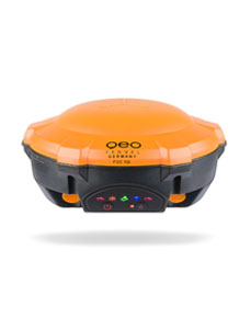
The new geo-FENNEL GNS receiver FGS 100 is, due to its unique-in-its-class compact design, a reliable partner in the field, given its suitability for working under rough conditions and in difficult terrain. It is equipped with an internal TILT-sensor and compensates slopes of the antenna pole up to 30°.

This function makes the survey job much easier than before. Equipped with a powerful UHF modem (Rx & Tx), Wi-Fi and a 4G modem, it offers a variety of connectivity options.

The receiver with its 572 channels supports all available GNSS sources, such as GPS, GLONASS, GALILEO and BEIDOU without the need for further activation. The system is open to third-party software and supports the Carlson SurvCE and
MicroSurvey® FieldGenius software solutions.

  • Working distance of internal UHF varies in different environments; the maximum distance is 5 km in ideal situations

  • Works with all kinds of CORS-systems worldwide

  • Integrated TILT-sensor with an accuracy up to 3 cm

  • Small and handy design

  • Supports MicroSurvey Field- Genius and Carlson SurvCE

Signal Tracking

  • Channels, which are simultaneously tracked: 572
  • GPS: L1, L2, L2C, L5
  • GLONASS: L1, L2
  • GALILEO: E1, E5a, E5b
  • BEIDOU: B1, B2, B3
  • QZSS: Yes (reserved)
  • SBAS: WAAS, EGNOS, MSAS, GAGAN


Performance Specifications

  • Cold start: < 50 s
  • Warm start: < 30 s
  • Hot start: < 15 s
  • Initialisation time: < 10 s
  • Signal reacquisition: < 2 s
  • Initialisation reliability: > 99.9 %
  • Tilt sensor: Up to 30°


Positioning Specifications

  • Static:
    – Horizontal: 2.5 mm + 0.5 ppm RMS
    – Vertical: 5.0 mm + 0.5 ppm RMS
  • Real-time kinematic(RTK)
    – Horizontal: 8.0 mm + 1 ppm RMS
    – Vertical: 15.0 mm + 1 ppm RMS
  • E-RTK (< 100 km)
    – Horizontal: 0.20 m + 1 ppm RMS
    – Vertical: 0.40 m + 1 ppm RMS
  • DGPS: < 0.4 m RMS
  • SBAS: 1 m 3D RMS
  • Stand-alone: 1.5 m 3D RMS


Data Communication

  • 1 serial port (7-pin LEMO) baud rates up to 921,600 bps
  • UHF modem Tx/Rx with a frequency range from: 410−470 MHz
  • Transmitting power: 0.5 − 2 W
  • Range 1 − 5 km
  • Wi-Fi/4G modem:
    4G bands: 800 / 900 / 1,800 / 2,100 / 2,600 MHz
    3G bands: 900 / 2,100 MHz
    2G bands: 900 / 1,800 MHz
  • Support GSM, point to point/points and NTRIP:
  • Position data output rates: 1 Hz, 2 Hz, 5 Hz, 10 Hz, 20 Hz
  • 5 LEDs: Indicating power, satellite tracking, GPRS status and
    differential data
  • Bluetooth®: V 4.0 protocol, compatible with Windows OS
    and Android OS


Data Format

  • Correction data I/O: RTCM 2.X, 3.X, CMR, CMR+
    (GPS only)
  • Position data output:
  • ASCII: NMEA-0183 GSV, RMC, HDT, VHD,
    GGA, GSA, ZDA, VTG, GST; PTNL,
    PJK; PTNL, AVR; PTNL, GGK
  • geo-FENNEL Binary update to: 20 Hz


Physical

  • Size: Ø 15.8 cm × 7.5 cm
  • Weight: 0.95 kg with two batteries


Environmental

  • Operating temperature: -40 °C to + 65 °C
  • Storage temperature: -40 °C to + 85 °C
  • Humidity: 100% condensation
  • Waterproof and dustproof: IP67
  • Shockproof: Designed to survive a 2 m drop onto
    concrete


Electrical and Memory

  • Input voltage: 5−27 VDC
  • Power consumption: 3.1 W
  • Power supply: 2 × 2,000 mAh, up to 9 hours typically
  • Internal memory: 8 GB


    captcha

    © 2024Geoapplied Co.Ltd. All rights reserved.

    Powered by Insight Web Studio