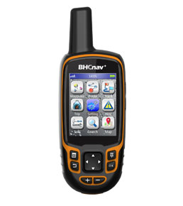
NAVA® Pro F70
Price: $ 330
NAVA® Pro F70 is a full-featured handheld GPS and GLONASS receiver with 2.8” display, and an ideal rugged GPS receiver for a large range of applications from agriculture, forest, surveying, mining and more outdoor works…
| GPS and GLONASS | |
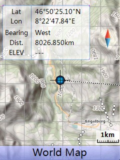 |
Supports Vector (City detail map), DEM map, and Raster map (open street map and google map etc.) |
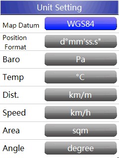 |
Unit setting |
 |
Device setting |
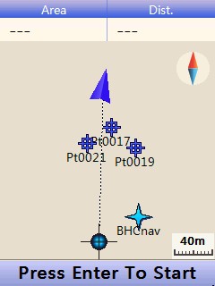 |
Area and perimeter |
| Physical & Performance: | |||
| Unit dimensions, WxHxD: | 6.2 x 17.2 x 3.6cm | ||
| Display resolution, WxH: | 240×320 pixels, QVGA | ||
| Display size, WxH: | 2.8” | ||
| Display type: | Transflective TFT, 65K colors | ||
| Weight: | 197g (with Lithium battery) | ||
| Battery: | 2×AA; Lithium Battery | ||
| Battery life: | 2xAA (up to 15 hours), Li-ion (up to 20 hours) | ||
| Waterproof: | IPX7 | ||
| High-sensitivity receiver: | Yes (72 parallel channels) | ||
| Interface: | USB and NMEA 0183 compatible | ||
| Maps & Memory: | |||
| Basemap: | Preload Worldwide basemap | ||
| Ability to add maps: | Yes | ||
| Built-in memory: | 4GB | ||
| Accepts data cards: | Yes (microSD™ card 32G) | ||
| Waypoints/favorites/locations: | 3000 | ||
| Routes: | 200 | ||
| Track log: | 400 | ||
| GPS Performance : | |||
| GPS accuracy : | 3-7m (GPS/GLONASS) | ||
| 1-3m (GPS with SBAS) | |||
| Features: | |||
| Automatic routing: | Yes (with optional mapping for detailed roads) | ||
| Geocaching-friendly: | Yes | ||
| Custom maps compatible: | Yes | ||
| Outdoor GPS games: | Yes | ||
| Hunt/fish calendar: | Yes | ||
| Sun and moon information: | Yes | ||
| Area calculation: | Area and Perimeter Calculation | ||
| Custom POIs : | Yes | ||
| Google data compatible: | Yes | ||
| AVG: | Yes | ||
| Calculator: | Yes | ||
| Military grid reference system coordinates : | Support | ||
| PC Support Software: | |||
|
|||
© 2015 - 2026 Geoapplied Co.Ltd. All rights reserved.
Powered by Insight Web Studio