NAVA® Pro F78
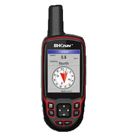
NAVA® Pro F78 is a full-featured handheld GPS and GLONASS receiver with 2.8” display, multiple built-in sensors, and an ideal rugged GPS receiver for a large range of applications from agriculture, forest, surveying, mining and more outdoor works…
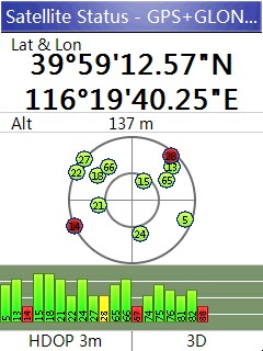
| • NAVA® Pro F78 is a full-featured handheld GPS and GLONASS receiver with quad helix antenna, with its high-sensitivity, WAAS, EGNOS, GAGAN, MSAS-enable GPS receiver, NAVA® Pro F78 locates your position quickly and precisely and maintains its GPS location even in heavy cover and deep canyons. | |||||
| • NAVA® Pro F78 has an enhanced 2.8", QVGA, 65K color, 240x320 pixels, sunlight-readable display. | |||||
| • Portable, rugged and capable of floating on the water. | |||||
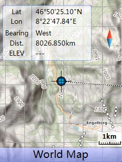
| • Worldwide basemap preloaded, and NAVA® Pro F78 also supports Vector (City detail map), DEM map, and Raster map (open street map and google map etc.). | |||||
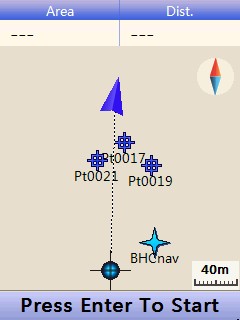
| • NAVA® Pro F78 lets you share your waypoints, tracks, routes in multiple GPS data formats, including GPX, SHP, MIF, CSV, KML, DXF, and TXT via NAVA GPS Office software. | |||||
| • NAVA® Pro F78 is an ideal rugged GPS and GLONASS receiver for a large range of applications from Agriculture, Forest and Biology, Mining, Surveying, Nautical, Hydrographic studies, Engineering disciplines,Geographical (GIS) and Urban information systems,Municipalities and Public works directorates, Electricity, Electronics, Geological studies, Sporting, National Real Estate-land survey directorates, Remote sensing, Public sector and institutions, Planning and First draft projects, Military... | |||||
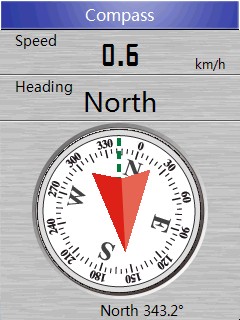
| • Built-in Sensors, Barometric altimeter, 3-axis E-compass and Thermometer. |
|
|||||||||||||||||
| Physical & Performance: | |||
| Unit dimensions, WxHxD: | 6.2 x 17.2 x 3.6cm | ||
| Display resolution, WxH: | 240×320 pixels, QVGA | ||
| Display size, WxH: | 2.8'' | ||
| Display type: | Transflective TFT, 65K colors | ||
| Weight: | 197g (with Lithium battery) | ||
| Battery: | 2×AA; Lithium Battery | ||
| Battery life: | 2xAA (up to 15 hours), Li-ion (up to 20 hours) | ||
| Waterproof: | IPX7 | ||
| High-sensitivity receiver: | Yes (72 parallel channels) | ||
| Interface: | USB and NMEA 0183 compatible | ||
| Maps & Memory: | |||
| Basemap: | Preload Worldwide basemap | ||
| Ability to add maps: | Yes | ||
| Built-in memory: | 4GB | ||
| Accepts data cards: | Yes (microSD™ card 32G) | ||
| Waypoints/favorites/locations: | 3000 | ||
| Routes: | 200 | ||
| Track log: | 400 | ||
| GPS Performance : | |||
| GPS accuracy : | 3-7m (GPS/GLONASS) | ||
| 1-3m (GPS with SBAS) | |||
| Features: | |||
| Automatic routing: | Yes (with optional mapping for detailed roads) | ||
| Geocaching-friendly: | Yes | ||
| Custom maps compatible: | Yes | ||
| Outdoor GPS games: | Yes | ||
| Hunt/fish calendar: | Yes | ||
| Sun and moon information: | Yes | ||
| Area calculation: | Area and Perimeter Calculation | ||
| Custom POIs : | Yes | ||
| Google data compatible: | Yes | ||
| AVG: | Yes | ||
| Calculator: | Yes | ||
| Electronic altimeter: | Yes | ||
| Barometric altimeter | Yes | ||
| Thermometer | Yes | ||
| Military grid reference system coordinates : | Support | ||
| PC Support Software: | |||
|
|||
© 2015 - 2026 Geoapplied Co.Ltd. All rights reserved.
Powered by Insight Web Studio