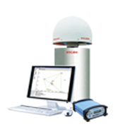
Reference Station


|
Satellite Signal Tracked Simultaneously |
|---|
| GPS: L1C/A,L1C,L2C, L2E, L5 |
| GLONASS: L1C/A, L1P, L2C/A, L2P, L3 |
| SBAS: WAAS, EGNOS, MSAS |
| Galileo: E1, E5A, E5B (test) |
| Beidou: B1, B2 |
|
Positioning Accuracy |
| Code Differential GNSS positioning: Horizontal: 25cm+1ppm RMS Vertical: 50cm+1ppm RMS Initialization time: typically<8s Initialization reliability : typically >99.9% |
| Real Time Kinematic (RTK): Baseline<30km Horizontal: 8mm+1ppm RMS Vertical: 15mm+1ppm RMS Network RTK Horizontal: 8mm+0.5ppm RMS Vertical: 15mm+0.5ppm RMS Initialization time: typically<8s Initialization reliability : typically >99.9% |
| Static Surveying (Post-processing):Single base<30km Horizontal: 3mm+0.5ppm RMS Vertical: 5mm+0.5ppm RMS Single base>30km Horizontal: 4mm+0.5ppm RMS Vertical: 9mm+0.5ppm RMS |
|
Communication & Data Storage |
|
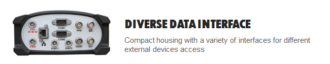
RS-232 (9pin) serial port, supports Host computer mode operation. Fully integrated and sealed 2.4GHz communication Bluetooth module. Ethernet protocol: HTTP, HTTPS, TCP/IP, UDP, FTP, NTRIP. Support proxy server and routing table. |
|
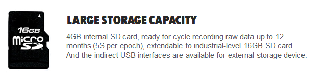
Data Storage: Internal Memory 4GB, recording raw data up to 12 months (5s per epoch), extendable to industrial-level 16GB SD card. And the indirect USB interfaces are available for external storage device. Update Rate: 1Hz, 2Hz, 5Hz, 10Hz, 20Hz, 50Hz positioning output.(depends on installed option, default 1Hz) Reference Output: CMR, CMR+, RTCM2.1, RTCM2.2, RTCM2.3, RTCM3.0, RTCM3.1 Navigation output: ASCⅡ, NMEA-0183, GSV, AVR, RMC, HDT, VGK, VHD, ROT, GGK, GGA, ZDA, GLL, GRS GBS and the binary: Trimble GSOF |
|
User Interface |
|
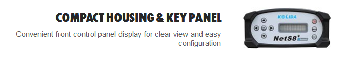
Front panel display with buttons and LED screen. One RJ45 Ethernet port (10M/100M), supports TCP/IP, HTTP, Ntrip protocol (supported by mainboard BD970). Two RS232 data ports, transmit static data and differential correction data. Two multi-functional ports: Port1 supports system debugging and static data download from internal SD card; Port2 supports parameters configuration and connecting meteorological sensor/barograph/inclinometer as well as external storage disk to extend storage capacity. One external frequency scale port, supports high-precision atomic clock connection. One PPS output port. |
|
Physical & Environmental |
|
Dimension(LxWxH): 202mmx 163mmx 75mm Weight: 1.4kg (include all module and battery) Working Temp. : -45℃ to +75℃ Storage Temp.: -40℃ to +80℃ Humidity: 10~95% non-condensing, RH(relative humidity). Water/ Dust Proof: IP67, waterproof for temporary immersion to a depth of 1m, dustproof. Shock and Vibration: rugged aluminum case + plastic ring seal, designed to survive from a 1m drop onto concrete. |
|
Electrical |
| External Power Input: 9-28V DC (with over-voltage protection) Power consumption: 4.0W Internal Battery Life: 10-15 hours |
© 2015 - 2026 Geoapplied Co.Ltd. All rights reserved.
Powered by Insight Web Studio