TheoDist® FTD 02
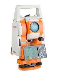
Reflectorless Total stations
The geo-FENNEL TheoDist® is designed to be user- friendly and quick to set up on any construction site. Easy to handle, robust, exact and reliable.
The main features of the geo-FENNEL TheoDist® are:
Measuring programs that provide efficient and easy solution for setting out
Three-dimensional measurement of coordinates
Menu driven software with intuitive structure to maximise productivity
A visible laser pointer to improve targeting accuracy and allowing measurements to be taken without looking through the telescope
Data can be uploaded and downloaded to a PC via the RS-232 connection or SD-Card (FTD 02)
Measuring range of up to 300m (FTD 05: 200m) without reflector
Quick and easy set-up with the integrated laser plummet
The geo-FENNEL TheoDist® Series is equipped with a variety of programs from simple distance and angle measurement up to precise three-dimensional setting out.
Missing Line
Offset
Remote elevation measurement
Resection
Integrated application programs for setting out office generated designs.
Area
The communication software supplied with the geo-FENNEL TheoDist® allows the user to save the data in various formats. The data files can be converted into DXF format making them suitable to be uploaded into CAD Software such
as AutoCAD®.
Telescope :
Distance measurement :
Measuring time :
Angle measurement :
Compensator :
Laser pointer :
Laser plummet :
Display :
Power :
Vial sensitivity :
General specs :
© 2015 - 2026 Geoapplied Co.Ltd. All rights reserved.
Powered by Insight Web Studio